Fairfax County planners want to add 2 miles of sidewalk and 1.5 miles of bike facilities along Route 29 in West Falls Church. McLean residents use the corridor to reach the Mosaic District and Falls Church.
The Fairfax County Department of Transportation (FCDOT) presented the recommendations at an Oct. 14 public meeting at Timber Lane Elementary School, as first reported by FFXnow. The proposals include a shared-use path, wider sidewalks, new crosswalks and pedestrian refuge islands along the 2-mile stretch between the Capital Beltway (I-495) and Tripps Run at the Falls Church border.
Residents who want a say in the final plan can take an online survey. The survey page lists a deadline of 5 p.m. on Nov. 9, while FFXnow reported a Nov. 6 close.
"It's better than [what] we've got now, but that's a pretty low bar," said Keith Henning, a McLean resident who frequents Route 29 to visit Mosaic and Falls Church.
What the plan calls for
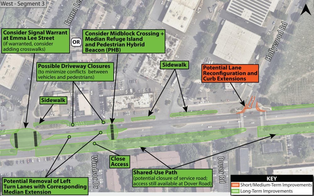
On the western end, planners recommend building a shared-use path on the south side of Route 29 while widening sidewalks or filling gaps on the north side. Some existing service roads would be replaced by pedestrian facilities or narrowed to a single one-way lane. Some driveways would be closed.
The shared-use path would end at Graham Road. East of that intersection, FCDOT proposes wider sidewalks on both sides of the road.
Other changes include crosswalks and pedestrian refuge islands at Shreve Road, Hyson Lane and Graham Road, along with bus stop improvements near West Street. A tree-lined median would replace eastbound left-turn lanes in front of the National Funeral Home and Memorial Park.
FCDOT project manager Nanditha Paradkar said the improvements would add 1.5 miles of bicycle facilities and about 2 miles of new sidewalk, according to FFXnow. A traffic analysis found "no substantial change" in rush-hour delays at signalized intersections, and crashes are expected to decrease.
Timeline and approval
The recommendations are split into short-term improvements that could be built in two to five years and long-term work expected to take 15 to 20 years, Paradkar said at the meeting, according to FFXnow. Funding has not been identified.
FCDOT must also coordinate with the Virginia Department of Transportation (VDOT), which owns the right-of-way and operates the corridor's traffic signals, according to county transportation records. FFXnow reported that the proposals need VDOT approval.
The study began in July 2025 and is expected to be completed by the end of 2026, when FCDOT plans to deliver a final report to the Fairfax County Board of Supervisors for approval.
Residents want more, faster
Attendees at the Oct. 14 meeting generally supported the proposals but pushed for bolder changes. Mike Garcia, chief of FCDOT's transportation planning section, acknowledged the tension between residents wanting more comprehensive improvements and wanting them built quickly.
Eliot Forster-Benson, who attended the meeting, said he was disappointed that only 1.5 miles of bike facilities are planned but welcomed the sidewalk connections. He suggested the county add flex posts or another interim fix at Shreve Road until permanent redesign work begins.
Henning argued that traffic delays, measured in seconds, should not block safety improvements. He said he would bike more for local trips if the infrastructure existed.
The survey is the third round of public input on the study, following workshops in November 2025 and May 2026. FCDOT expects to send its final recommendations to the Board of Supervisors by the end of 2026.